
Indian River County flood zone map
Indian River County flood zone map
Indian River County's FEMA flood map puts high-risk land in zones that start with A or V. If your home is in one and your loan is federally backed, your lender has to require flood insurance.
Checked against FEMA’s flood map for that exact spot.
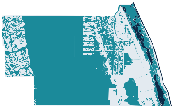
- High risk (A zones)
- High risk, with waves (V zones)
- Outside the high-risk zones
High-risk flood zones on FEMA's flood map for Indian River County. Your exact address decides your zone.
Is my address in a high-risk zone?By the numbers
Indian River County flood insurance by the numbers: how many policies are in force?
Yours depends on the home.
Off eligible NFIP flood premiums.
Does my lender require it?
What does each zone on the Indian River County map mean?
The letter decides the requirement. It does not decide your price. The building does.
Coastal land where waves push in, not just rising water. Zone VE has the strictest building rules.
Land with at least a 1% chance of flooding in any year. Zone AE shows the base flood elevation, the height the water is expected to reach.
Land outside the A and V zones is Zone X. A lender does not have to require flood insurance there. FEMA still rates Zone X as moderate or minimal risk, not no risk.
What sets the price
Same flood zone, very different prices in Indian River County. Here is why.
Your flood zone decides if your lender requires a policy. Under Risk Rating 2.0, the price depends on the home: how often it could flood, how close it sits to the water, its first floor height and what it would cost to rebuild.
An elevation certificate shows your first floor height against the base flood elevation. See Indian River County's elevation certificate page.
Checked against FEMA’s flood map for that exact spot.
Quick answers
Questions about the Indian River County flood zone map?
How can I find my flood zone in Indian River County?
Type your address in the ShoutFlood address check at the top of the page. It reads FEMA's flood map for that spot and shows your zone. You can also search the Indian River County Search Your Flood Information (Forerunner) or FEMA's Flood Map Service Center.
How can I check if my address is in a flood zone in Florida?
Enter your address in the ShoutFlood check, or search FEMA's Flood Map Service Center, which covers every Florida address.
What flood zones in Florida require flood insurance?
Zones that start with A or V are the high-risk area. If your home is there and your loan is federally backed, your lender has to require flood insurance. Zone X is outside that area, so the lender does not have to require it. FEMA still rates Zone X as moderate or minimal risk, not no risk.
What's the worst flood zone to be in?
V zones, and Zone VE most of all. VE means waves, not just rising water, and the strictest building rules. Still, the zone decides the requirement, not the price. The price depends on the home, so two Indian River County homes in the same zone can pay very different amounts.
ShoutFlood is not affiliated with FEMA or the NFIP.
Keep reading
Zone AE on the map: does your lender require a policy?
More county flood zone maps
One clear next step
Check your Indian River County address
Your flood zone and your community's discount, in one check.
Or call or text (727) 516-0111.